Property Record
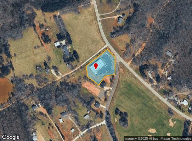
1785 Stockton Farm Rd, Pendergrass, GA 30567

NEARBY LISTINGS FOR SALE OR LEASE
-
-
View all Pendergrass listings for sale on LoopNet.com
Property Detail
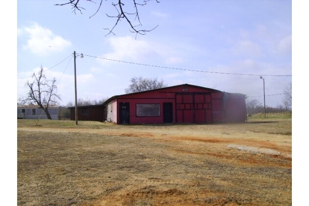
1785 Stockton Farm Rd
089-018U
1.53 AC TRACT 1 PLAT BOOK 41 PAGE 58
Autorepair
Jackson
X
Georgia
13139C0350G
1.53 AC
2025
E Jackson
2024
Atlanta
010200
Jefferson, GA
8,100 SF
DEMOGRAPHICS near 1785 Stockton Farm Rd
1 Mile
3 Mile
5 Mile
2024 Total Population
736
3,235
14,147
2029 Population
966
4,197
17,653
Pop Growth 2024-2029
+ 31.25%
+ 29.74%
+ 24.78%
Average Age
40
40
37
2024 Total Households
254
1,093
4,534
HH Growth 2024-2029
+ 29.92%
+ 28.36%
+ 23.95%
Median Household Inc
$70,555
$58,246
$68,174
Avg Household Size
2.80
2.80
3.00
2024 Avg HH Vehicles
3.00
3.00
2.00
Median Home Value
$512,626
$371,874
$337,228
Median Year Built
2002
1995
1999
Nearby Places
Map Layers
Map Styles
 Street
 Aerial
- Restaurants
- Banks
- Shops
- Fitness
- Groceries
Nearby Properties
Address
Land Use
TOTAL SIZE
Lot Size
Zoning
Address
Land Use
TOTAL SIZE
Lot Size
Zoning
1,004,400 SF
61.31 AC
L1
Address
Land Use
TOTAL SIZE
Lot Size
Zoning
999,205 SF
74.81 AC
L-I
Address
Land Use
TOTAL SIZE
Lot Size
Zoning
78.68 AC
001
Address
Land Use
TOTAL SIZE
Lot Size
Zoning
801,420 SF
80.72 AC
L-I
Address
Land Use
TOTAL SIZE
Lot Size
Zoning
850,500 SF
57.87 AC
I
Address
Land Use
TOTAL SIZE
Lot Size
Zoning
916,560 SF
82.80 AC
004
Address
Land Use
TOTAL SIZE
Lot Size
Zoning
1,053,360 SF
101.96 AC
001
Address
Land Use
TOTAL SIZE
Lot Size
Zoning
772,000 SF
86.10 AC
LI
Address
Land Use
TOTAL SIZE
Lot Size
Zoning
815,112 SF
104.67 AC
LI
Address
Land Use
TOTAL SIZE
Lot Size
Zoning
1,120,106 SF
66.43 AC
Address
Land Use
TOTAL SIZE
Lot Size
Zoning
719,200 SF
113.14 AC
M1
Address
Land Use
TOTAL SIZE
Lot Size
Zoning
366,300 SF
123.06 AC
I2
Address
Land Use
TOTAL SIZE
Lot Size
Zoning
848,000 SF
60.86 AC
I2
Address
Land Use
TOTAL SIZE
Lot Size
Zoning
242,306 SF
32.76 AC
I2
Address
Land Use
TOTAL SIZE
Lot Size
Zoning
518,125 SF
28.51 AC
I2
Address
Land Use
TOTAL SIZE
Lot Size
Zoning
151.22 AC
MI
Address
Land Use
TOTAL SIZE
Lot Size
Zoning
202.89 AC
GI
Address
Land Use
TOTAL SIZE
Lot Size
Zoning
92,004 SF
233.70 AC
001
Address
Land Use
TOTAL SIZE
Lot Size
Zoning
128,830 SF
12.24 AC
I2
Address
Land Use
TOTAL SIZE
Lot Size
Zoning
117.91 AC
LI
Address
Land Use
TOTAL SIZE
Lot Size
Zoning
120,000 SF
12.52 AC
I2
Address
Land Use
TOTAL SIZE
Lot Size
Zoning
120,000 SF
10.33 AC
I2
Address
Land Use
TOTAL SIZE
Lot Size
Zoning
120,000 SF
7.41 AC
I2
Address
Land Use
TOTAL SIZE
Lot Size
Zoning
70.44 AC
L1
Address
Land Use
TOTAL SIZE
Lot Size
Zoning
120.50 AC
004
Address
Land Use
TOTAL SIZE
Lot Size
Zoning
24.05 AC
RI
Address
Land Use
TOTAL SIZE
Lot Size
Zoning
216.31 AC
001
Address
Land Use
TOTAL SIZE
Lot Size
Zoning
195.33 AC
001
Address
Land Use
TOTAL SIZE
Lot Size
Zoning
255.13 AC
004
Address
Land Use
TOTAL SIZE
Lot Size
Zoning
279.94 AC
001
The World's #1 Commercial Real Estate Marketplace
Connect with us
© 2025 CoStar Group
The information above has been obtained from sources believed reliable. While we do not doubt its accuracy we have not verified it and make no guarantee, warranty or representation about it. It is your responsibility to independently confirm its accuracy and completeness. Any projections, opinions, assumptions, or estimates used are for example only and do not represent the current or future performance of the property. The value of this transaction to you depends on tax and other factors which should be evaluated by your tax, financial, and legal advisors. You and your advisors should conduct a careful, independent investigation of the property to determine to your satisfaction the suitability of the property for your needs.